Gamla

Our second day started with a tour of Gamla. Gamla was a city built in the Bronze Age (3,300-1,200 BCE) and ruined in the Hellenistic period after they revolted against the Romans in 67 CE. It was built on the side of a very steep cliff so that it could only be accessed by one trail leading in, and many of us took that same trail in to view the city. The city was forgotten about until it was discovered in 1968. There were many artifacts found at the site to evidence a large battle, such as arrowheads and ballista balls. 

The site is also home to the tallest waterfall in Israel, which many people also hiked to see.


Tel Hatzor

I was able to safely get back to America with a heavy heart that I had to leave Israel early. I was so impressed with the people in charge of the dig and their level of organization throughout our move around the country. I'm used to being in charge of my class, but our coordinators were in charge of about 70 people's travel arrangements, hotel bookings, and food. I'm lucky to be part of such a well organized dig.

With that being said, I will continue with my blog throughout the summer telling of the sites we were able to visit on our field trip around the country since they were so interesting.

Third up on tour was Tel Hatzor. The tel was the site of a major city from about 1750 to 900 BCE (before common era, the more commonly used term than BC). It was one of the largest in the region and located in the fertile crescent, an area that was very good at growing crops. It is located north of the Sea of Galilee and has been largely reconstructed by different archaeological groups.


Nimrod's Fortress

The second stop on our study tour was Nimrod's Fortress. It was built during the sixth crusade and was used as a place for security during an attack on Damascus and was added to throughout the 1200's. After the crusade, it was used by many other groups for things such as a prison for exiled nobles. 

We had a great time as Dennis explained the history of the fortress to us, and even more fun going down the "secret stairways" that wound throughout the different towers. We also had some great views of the valley below from the tall towers the fortress supplied!

There may not be a post tomorrow-I will be traveling home from Tel-Aviv and may not have internet access. There will be more posts to come once I land in Chicago!


Taking our group up north!

We’ve had to take our dig up North because of trouble happening in Ashkelon. I will be starting my blog from today on showing you some of the places we visit on our archaeological field trips and tell you the history behind them!

First up on our stop was Tel Dan. Tel Dan is one of the most northern cities in Israel, and is mentioned in the Bible. It has one of the oldest and most in-tact gates (we also have one at Ashkelon, watch the video here!) and was used throughout the Bronze age, Iron age, Hellenistic, and Roman periods.

We got the chance to hike to the gate and walk around to an alter where they made animal sacrifices. Our dig's zoo-archaeologist, Deirdre, told us all about the animals they have found here--which included 2 lions!


GIS map making

Did you know that every time we work in a new area in our grid, its coordinates are read so we can make 3D maps? 

Grant, Grid 51's GIS worker (GIS stands for geographic information systems) will show you how the readings work. 

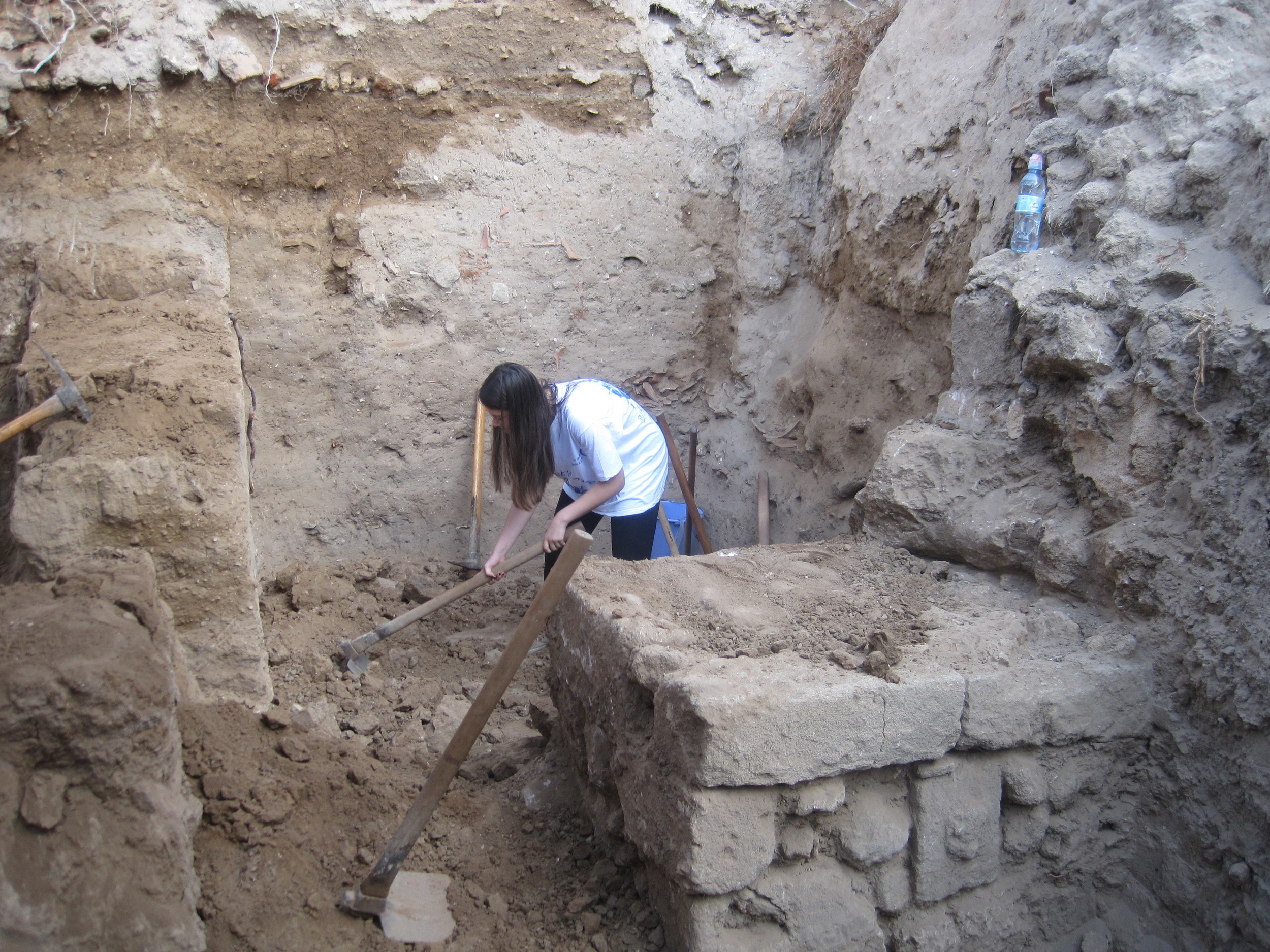
Do you see Joel holding the red and white stick? That is the location we are taking a measurement of. 

For every area, we take a reading when we go down a level in time. This means that even though it is the same space, we could take multiple coordinates so we know how high each level is when a new time period starts. These levels can then be matched up with buckets of pottery we collect or with specific artifacts we find.

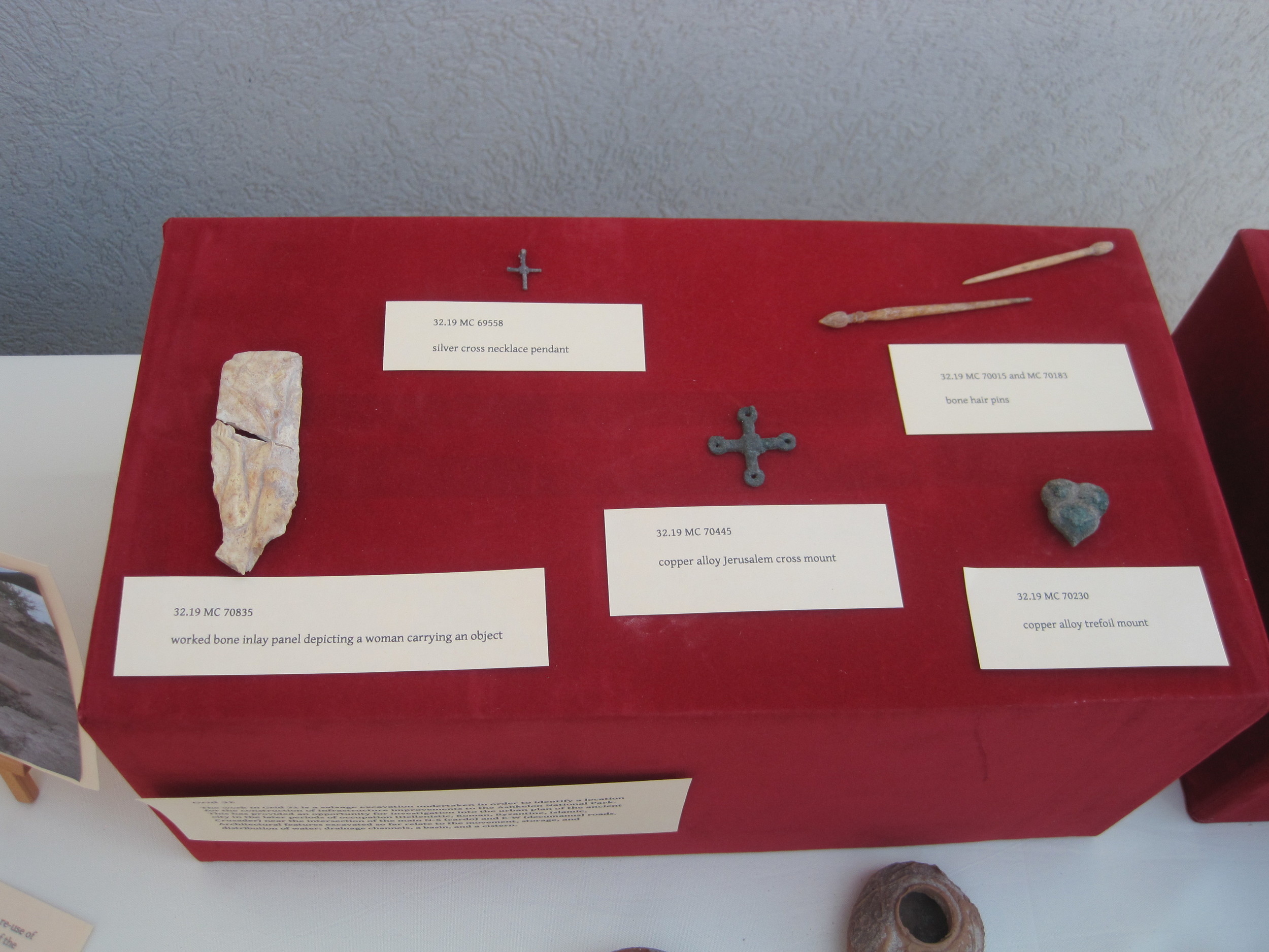
Taking the GIS coordinates for the location and elevation helps us see patterns when we find artifacts, even if we are not digging in the same level across our grid. This can help us determine what that space was used for and what it used to look like. 

I will be posting a module soon on triangulation and GIS coordinates, so make sure to check back on our modules page if you want to learn more.

Junior Archaeologist Assignment:

Look at different objects around your house that have different heights. What would you use to measure them? A ruler? A yardstick? Use your log book to record how tall at least 5 objects are and what tool you used to measure them. 

Question of the Day:

Why do you think that archaeologists don't just measure how high things are in the field? What could be the problem with just measuring how high a wall is or how deep down a well goes?

Infrared Light and Carbon Dating

One of the people who works on the dig, Bridgett, recently had the chance to tell me about her work with the soil samples she collects from different dig sites. Bridgett is the one who we call in if we see the ground is a funny color and we want to know what happened to it in the past. She is able to put the samples in an infrared spectrometer and read the levels of all the elements to tell us what it is. It is very useful in finding out if a fire occurred there, if the spot was used for cooking, or if there are parts of bone in the soil. Knowing this information can tell us what that space was used for and help us piece together the clues of what the different rooms are that we excavate. Check out her video below to hear more! 

If you are interested in learning more about infrared light and carbon dating, head over to our modules page to see our lesson. 


Junior Archaeologist Assignment:

Ask a parent to find 3 different white powders from your kitchen or spice cabinet and make small piles of them on a plate without telling you what they are. In your log book, record all of their properties (what you can see) and make note of how they are different. Next, brainstorm a way to run tests to see what the different powders are. Is there any liquids you could drop on the powders to solve the mystery? How else could you tell what these powders are than just asking your parent to tell you?

Question of the Day:

Why do you think it would be important for scientists to know what was located in different areas? Do you think that the areas were always used for the same thing?

Celebrating the 4th of July on the 7th of July

For many of our volunteers and staff, we spend the majority of the summer in Israel working on the dig. Some supervisors are away as long as 2 months!  They spend time preparing the dig sites, setting up a game plan of what they would like to dig, dig, then get everything put away and stored so they can study it when they go home.

To feel like home for a little bit, one of the girls who comes along on our dig every year (her dad is the dig coordinator) plans a 4th of July party! We had a great time playing cards by the pool, eating cookies, and relaxing. It was great after our long day digging!


Finds presentation

Every year, the supervisors put together a finds presentation of some of the neat artifacts they have dug up in their grid. We recently had the presentation which included items found from the end of the 2013 season and the beginning of the 2014 season. Check out some of the pictures to see if you can recognize any of the objects!

Jerusalem 005.JPG


Jerusalem 008.JPG
The supervisors and volunteers of Grid 51.

The supervisors and volunteers of Grid 51.

Setting up the grid system at Ashkelon

Here on the dig, I work in grid 51-but we also have volunteers working in grid 16 and 20. I knew these were areas around our dig site, but I wasn't quite sure how these grids were numbered. 

I also noticed that when I was digging, we have three different squares within our grid, and finer squares within the big one that shows where all of our artifacts were coming from.  To get a better sense of how all these grids were laid out, I asked one of the square supervisors (go to this link to see what a square supervisor does!), Jonathan, to tell me how our dig at Ashkelon was divided up.

Junior Archaeologist Assignment:

Choose a room in your house and draw a map of it in your log book. What do you think the best way is to section it off? Divide your room into 10 equal squares (this may be easier if you use graph paper) and make notes of what is located in each of the squares. Take 3 things out of the room and have someone else in your family use the map to put the items back where they belong based on the information from the grid.

Question of the day:

Why do you think it is so important for archaeologists to use grids so they know exactly where all of the artifacts came from? Why would this information be important when they are identifying it?

Why do we have you keep log books?

In my science class, I have students keep science journals to record their data, answer questions, write procedures, and look back to reflect on past experiments.

Teachers don't just have you do this for fun, we are training you how to be good scientists! I was not surprised to see how many archaeologists here use log books every day in the grid to record their findings. With the internet being unpredictable and the fact that everyone has to keep track of a lot of information every day, log books are the way to keep your findings organised. It is our hope in having you write in your log book for every module that you see what a valuable tool it can be!

Watch as Emily, an assistant square supervisor, explains the way that she uses her log book in the field.

Junior Archaeologist Assignment:

Either using the log book from previous blog posts or a brand new notebook, start recording what you see around you! What questions do you have about what you see during the day, and how could you find the answers to those questions? You will be using this log book throughout future blog posts, so make sure you keep it neat and in a safe spot where you won't lose it!

Question of the Day:

What do you think would happen if archaeologists didn't keep these log books? How might that change what they do in the field?

Volunteers, part 3

Here is my last post checking in with some volunteers to see why they came to Ashkelon.

As you can see, there are many different backgrounds and areas of study that can lead you to a dig, it doesn't just have to be archaeology. Many branches of math, science, arts, and social studies tie in!

Uploaded by Teach Ashkelon on 2014-06-25.

Uploaded by Teach Ashkelon on 2014-06-25.

Uploaded by Teach Ashkelon on 2014-06-25.


Volunteers, part 2

As promised, here are some more volunteers telling why they have chosen to come and dig at Ashkelon. It has been such a great learning experience getting to know everyone in the field!


Uploaded by Teach Ashkelon on 2014-06-25.

Uploaded by Teach Ashkelon on 2014-06-25.

Why come to Ashkelon?

Hopefully you've all had the chance to see some videos by our fabulous staff and coordinators here at the dig, but I thought I would introduce everyone to some of the volunteers here. Volunteers are usually college students who are studying some branch of archaeology and they come to Ashkelon to learn more about how an excavation works. Over the next couple of days, I will be showing you some videos of volunteers telling you what path they took to lead them to this Ashkelon dig. 

Of course, anyone could come to volunteer to dig at our site (just check out volunteer page!)

Uploaded by Teach Ashkelon on 2014-06-25.

How else can we use archaeology?

I've met a lot of really interesting people on the dig, one of which being Gordy. Gordy is an archaeologist in the United States, and he comes to do digs in Israel for vacation! 

At Gordy's work, they are hired to look in the ground for artifacts before any large things are built, like railroads or buildings. Companies do this so that they know they are not going to ruin any historical pieces as they are building.

Listen as Gordy tells you a little more about what he does.

Junior Archaeologist Assignment:

Look at the map on this page to see listings of digs around the world. Are they all looking for the same thing? What are the different sites in America? How are the digs alike and how are they different? Which one seems the most interesting to you, and what periods are they studying? Are all of the periods the same as what we study in Ashkelon? (Hint-Look at our vertical time line module to see the different periods we study)

Question of the Day:

How might what archaeologists find change based on where they are digging? For example, do you think archaeologists would find the same things in Massachusetts that they find in Nevada? Who were the people that lived in these different regions?

Community day at the dig site.

This week at the different dig sites, students in 6th-10th grade from Ashkelon came to visit and help us dig. We showed them the different tools we use, how to remove different layers of mud brick and rock, and how the items we found might have been used in homes before. In return, students had the chance to teach us some Hebrew and ask questions about living in America. It was a great day for community involvement and for the chance to show these students the history of their city.

Junior Archaeologist Assignment:

Look for archaeological opportunities around where you live! Are there places you can see at museums or through the Boy Scouts that may help you learn more about archaeology field work? (If you live in the Chicago area, look at this offering through the Field Museum!)

Question of the Day: 

Why do you think our dig thinks it's so important to show students in our area the different grid sites and how we dig?

What happens to those pottery pieces that we find?

Uploaded by Teach Ashkelon on 2014-06-25.

Before coming to Ashkelon, I always wondered what happened between finding the pots in the ground and putting them together. When arriving at the dig compound, I had the chance to see the in-between phases that allows the dig workers to publish the pieces they find and make them available for others to study.

As you will see in the video, there are many steps for putting together the pieces of pottery back together. Lots of university student volunteers (who you will hear from throughout my blog updates) are needed to complete this task!

Question of the day:

Why do you think we spend so much time labeling all of the pottery pieces that we find? Do you think that all the pottery pieces we find are put back together again?

Answer!

You have had lots of time to think about it and now the much awaited answer to our last What in The World!? Meg, the microarchaeologist here in Ashkelon, shares one part of her job and in doing so reveals what this weeks What in the World is! 

Junior Archaeology Assignment:  In your log book draw pictures of other plants you think Meg might find pieces of when looking under her microscope.

Question of the Day: Why is it important for archaeologists to look at the diet of people living in ancient Ashkelon? 

Remember to e-mail me your pictures and ideas at kids@digashkelon.com. Looking forward to hearing from you!

What in the World?

Today’s what in the world is a tricky one!  There is a specialist who works on our excavation who looks at things like this on a daily basis.  What do you think it is? Who do the think the specialist is who looks at this? Post your ideas below or email me at kids@digashkelon.com!

long cell dendritic.jpg

Strike a Pose!

Did you know many of the artifacts we find here in Ashkelon are photographed and drawn?! Photographing and drawing the objects we find is an important step in understanding what is on the object, how it is shaped, and what other items we have found are similar to it. All of her photographs are put into our computer system so at any time we can look up photos and information about what has been found. It's like Google but for our Ashkelon excavation!

Our dig photographer, Melissa, takes photos of these small objects in her hotel room here. She has created a little studio in there and invited us in to take a look at how she does this part of her job.  

Junior Archaeology Assignment: Can you set up a photo shoot like Melissa does? Some things to think of: 

1. Choose an object

2. Make sure you have good light

3. Ask your parents to allow to or help you to use their camera! 

4. Set a scale next to the object so we know how big it is. This can be a ruler or a coin or anything that has a standard size. 

5. Shoot! Don't forget to shoot the different sides of the object! 

6. E-mail me your photos at kids@digashkelon.com

Question of the day: What would happen if Melissa didn't use a scale (ruler) when photographing objects?  What other sorts of things do you think Melissa photographs during the day?